
Linking oceanographic driven sediment flux to geologic records in Antarctic submarine canyons
Submarine canyons can serve as pathways for water, sediment and organic carbon transport to the deep ocean via dynamic processes – what are these processes in Antarctic submarine canyons and how might they be linked to, or contribute to, global ocean circulation and accumulation of sediment layers over time? Dr Katie Maier and Dr Jess Hillman aim to find out in this Opportunity Fund project.
Background
Previous research in and around the Hillary Canyon and canyon head gullies in the Ross Sea showed that the submarine canyons can serve as conduits for dense shelf-water cascading, contributing to bottom water formation and global ocean circulation. Antarctic submarine canyons can also provide pathways for warm water incursions (which may influence ice sheet retreat and future sea-level rise projections).
The Ross Sea region hosts areas of dense water formation and submarine canyon systems, but Antarctic canyon near-seafloor processes and links to oceanographic processes remain largely unmeasured. There is a pressing need to pair near-seafloor measurements and sediment samples from an Antarctic submarine canyon to link sediment flux and processes in high-latitude canyons, as well as contribute to assessing triggers of sediment density flows (e.g., turbidity currents), distinguishing down-slope (e.g., turbidity current) from along- slope lateral sediment transport, and interpreting seafloor deposition which records these processes.
The global role of submarine canyons is as conduits, funnelling terrestrial and marine sediment and organic carbon to the deep-sea, acting as biodiversity hotspots, feeding ecosystems, and building a record of past conditions through deposition of sediment layers. Recent success overcoming challenges to measuring and sampling in mid-latitude submarine canyon systems has advanced knowledge of submarine canyon processes, deposition, and what is considered possible in field experiments.
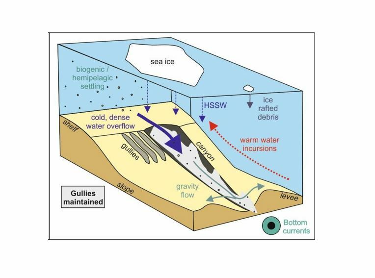
Schematic of modern Antarctic canyon processes from Gales et al. (2021). Sediment gravity flows transport fine-grained sediment down slope. HSSW: High Salinity Shelf Water.
Research overview
The Western Ross Sea contains submarine canyons in a region of dense shelf-water cascading. These will be targeted for a pilot study during the upcoming R/V Tangaroa voyage in January – February 2023.
As part of this voyage, technical experts onboard will deploy a mooring and sample the seafloor sediment in an Antarctic submarine canyon. The mooring will be focused on a sediment trap, similar to those used in recent studies of the Kaikōura Canyon, offshore northeastern Te Waipounamu South Island. The near-seafloor sediment trap will be paired with oceanographic instruments to measure parameters (for example, temperature, velocity, turbidity) associated with water masses carrying sediment past the trap. The sediment trap will be deployed for a full year to capture possible seasonal variability.
As part of the ASP Opportunity Fund project, Dr Maier and Dr Hillman will use the resulting measurements and samples from the sediment-trap-focused mooring and seafloor samples to:
- measure flows and sediment transported within an Antarctic submarine canyon, linking oceanographic processes with near-seafloor sediment transport and deposition;
- evaluate the relative importance of oceanographic and sediment density flows in transporting and depositing sediment through Antarctic canyons; and
- quantify how much sediment and organic carbon are transported within the canyon to support ecosystems or exported into the deep sea.
The new data will be nested within the broader context of Ross Sea margin geology, tectonics, and physical oceanographic measurements of the region, including new research undertaken on the upcoming 2023 R/V Tangaroa Antarctic voyage.
By producing an initial dataset, this project will fill a critical gap in global submarine canyon sediment transport process understanding and contribute to quantification of the role of dense water cascading and warm water incursion in submarine canyon sediment transport in the Ross Sea region. This will provide the basis from which to gauge anthropogenic induced changes in Antarctic submarine canyons and will also aid reconstructions of past oceanographic processes from sediment cores during climatic intervals warmer than present.

Bathymetric map and submarine canyons in the western Ross Sea Region offshore Cape Adare showing the Wilson Canyon. Map generated in GeoMapApp.

Deployment of a sediment-trap-focused mooring in Kaikōura Canyon on recent R/V Tangaroa voyage TAN2112 (O. Twigge, left; P. Gerring, right). Sediment passes through the open top of the yellow funnel and is collected in the bottles below. Photo: Katie Maier
Collaborators
- S. Deppeler (NIWA)
- O. Twigge (NIWA)
- Dr J.A. Gales (University of Plymouth, UK)
- Dr E. Pope (Durham University, UK)
- ASP Project 2 oceanographers and paleoceanographers