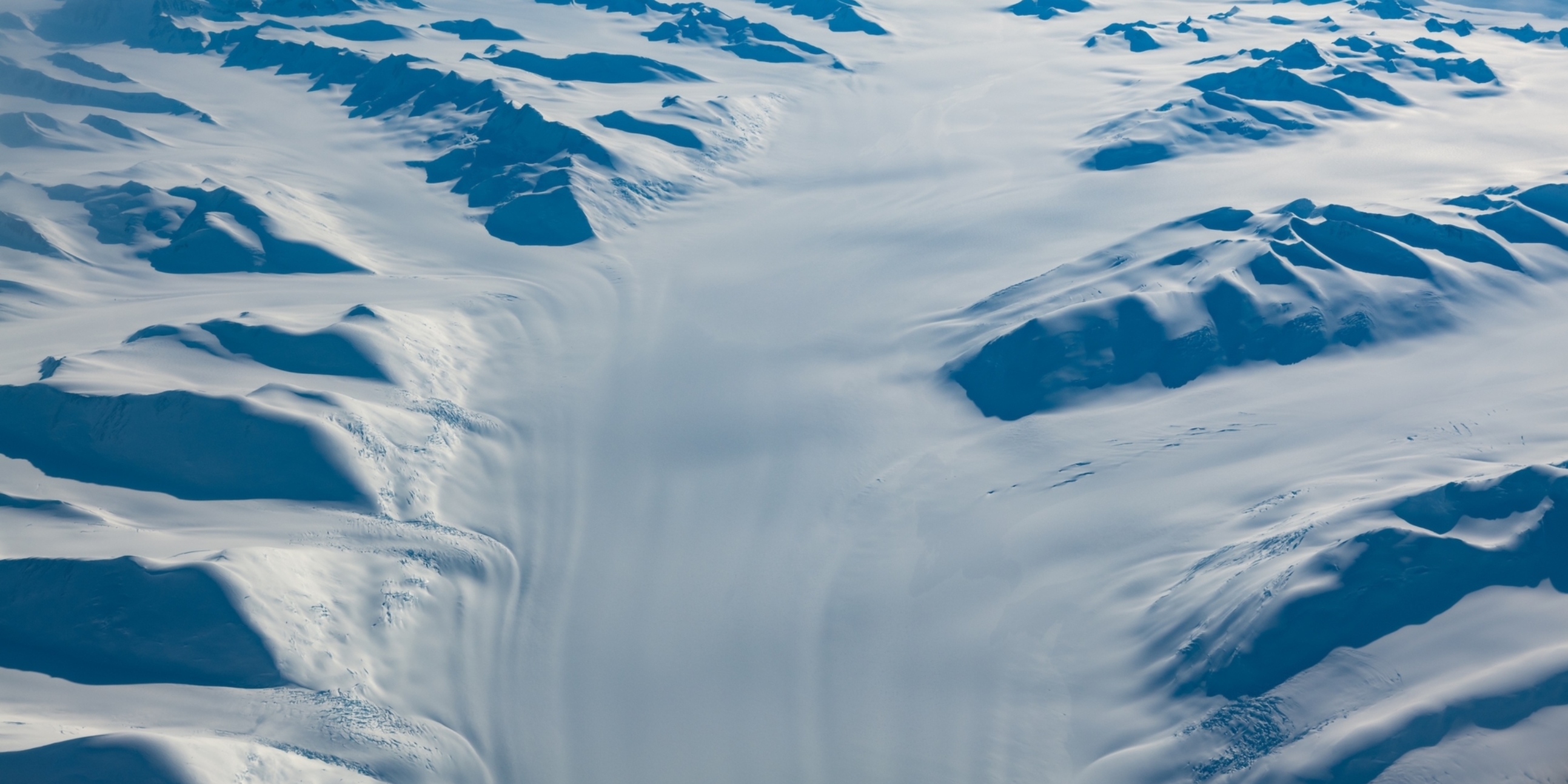
Figure 1: Glacier flow; Antarctic ice sheet. Photo: Anthony Powell
Case study: International drilling programme improves accuracy of projections for Antarctic ice loss and sea level rise
An Antarctic Science Platform-led international scientific drilling project is providing data to reconstruct past climate conditions and ice sheet behaviour, which informs sea level rise projections and Antarctica’s future response to climate change.
The future of the West Antarctic Ice Sheet
One of the four key goals of the Platform is to understand the stability of the West Antarctic Ice Sheet (WAIS). The WAIS remains the most prolific and uncertain contributor to future sea level rise and is presently losing mass at an accelerating rate. It holds enough ice, if melted, to contribute 4.3m to global sea level.
The WAIS drains through two regions, the Amundsen and Ross Sea sectors. While extreme melting in the Amundsen Sea region has led to staggering ice mass loss there, quantification of the ice mass balance (or health) of the ice draining through the Ross Sea is more complex. Antarctic Science Platform research is exploring these ice sheet dynamics, particularly the critical interaction between the Antarctic Ice Sheet and the Ross Ice Self, using geological and geophysical techniques in combination with advanced computer modelling to better understand and simulate past, present and future change.
One critical knowledge gap the Platform is addressing is the timing of past WAIS collapses and the environmental conditions that caused complete retreat in past warmer-than-present climatic conditions. Scientific drilling and core recovery is the key method for accessing valuable archives of past climate and ice sheet behaviour (historical temperature, precipitation, atmospheric composition, volcanic activity, and even wind patterns).
The SWAIS2C project
The Platform leads the international SWAIS2C project (Sensitivity of the West Antarctic Ice Sheet to 2°C), which aims to investigate whether the WAIS collapsed or partially retreated during the last time Earth experienced 1.5°C of global warming.
New Zealand and our international partners have developed a reputation for achieving seemingly impossible Antarctic missions. The SWAIS2C project is extraordinary challenging, even for this seasoned team. It's extraordinarily difficult: Drilling 860km from the nearest Antarctic base, through ~600m of ice shelf, plunging through the underlying ocean and into the elusive sediment below using a hot-water drill and a new lightweight sediment drilling system. Pushing the limits means that, from time to time, one finds them. This creates setbacks and delays, requiring an agile approach to solve problems and navigate another way to succeed.
As a strategic, long-term funder, the Platform has been instrumental in the establishment and implementation of the SWAIS2C project and in the strengthening of international collaborations. Once the Platform's funding, science goals and project plan were in place in 2020, additional partners joined to build a more encompassing programme. This has resulted in an 8-nation collaboration, adding resilience through a wider funding base and diverse expertise.
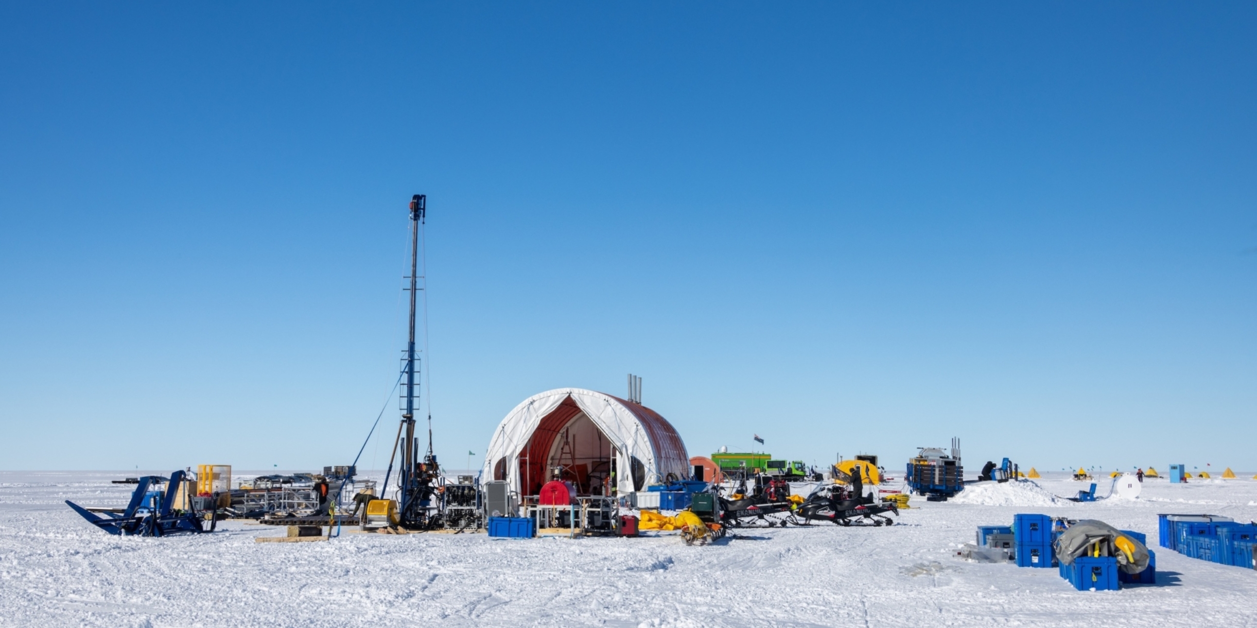
KIS3 drilling tent preparation. Photo: Anthony Powell/Antarctica New Zealand
Science journey to date
This ambitious scientific drilling programme is obtaining the sedimentary history at two locations near the modern grounding zone of the West Antarctic Ice Sheet. The first field seasons of the international SWAIS2C programme returned short 10m marine sediment cores from Kamb Ice Stream, along the Siple Coast in the West Antarctic interior (Figure 3), where the WAIS lifts off from the sea floor and begins to float. However, the longer ~200m records that will help to reconstruct past changes in the WAIS—to better understand how historic conditions drove ice sheet stability—remain elusive.
Our engineers have learned from the field experiences and taken big steps towards future drilling success. Meanwhile, the geophysics team completed mapping of the shape of the seafloor beneath the Ross Ice Shelf at Discovery Deep, and the geochronology team collected rock samples from the Transantarctic Mountains to better understand past ice sheet thinning rates.
Highlights from SWAIS2C field seasons include:
- traversing of equipment and personnel to and from the Siple Coast, over 1,000km from Scott Base
- hot water drilling ~600m through the Ross Ice Shelf
- servicing of GPS (ice shelf velocity) and radar (ice shelf thickness) measurements
- sub-ice shelf oceanographic observations in the ice cavity (CTD deployment in open hole)
- direct observations of subglacial flow important to understanding ice sheet dynamics|
- collection of two shallow marine sediment cores.
Overall, the oceanographic and glaciological data obtained during both drilling seasons, as well as the ~10m of sediment cores collected are now being exploited by the international science party to address the project’s scientific objectives. This includes ancient DNA and characterisation of microbial assemblages and physiological profiles.
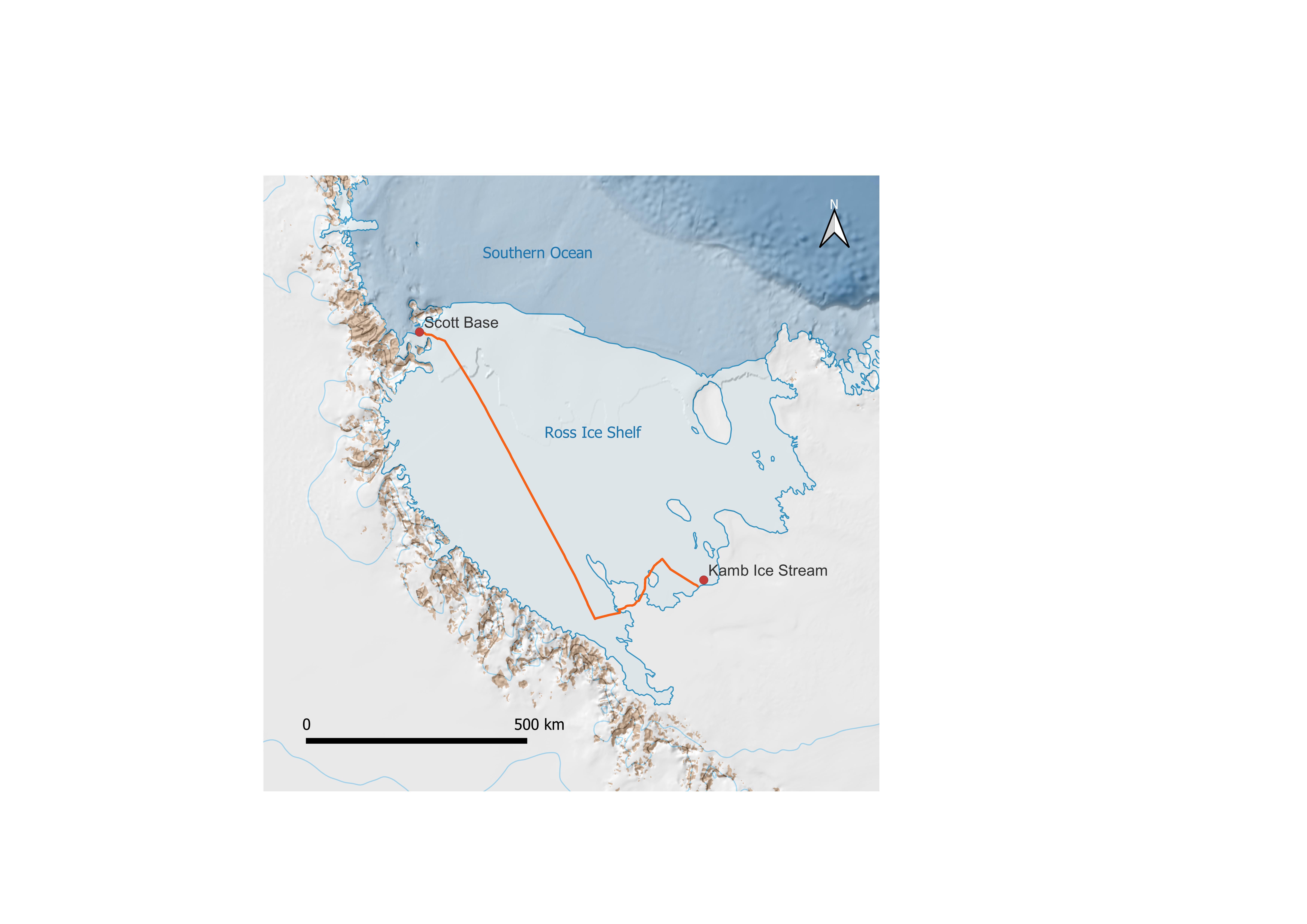
Figure 3: Overland traverse route from Scott Base to the Kamb Ice Stream, near the grounding zone of the West Antarctica Ice Sheet.
Map supplied by Antarctica New Zealand. Sourced from Quantarctica and the Norwegian Polar Institute. Retrieved 12 January 2024.
Improving sea level rise projections
The Platform research and SWAIS2C collaboration is providing critical information to learn just how sensitive West Antarctica is to a warmer climate, potentially impacting over 1 billion people. We are finding out whether our efforts to reduce greenhouse gas emissions can save the Ross Ice Shelf and the West Antarctic Ice Sheet, to limit global sea level rise.
Even at the current level of warming, we are committed to rising sea levels for hundreds of years. The Platform’s work has led to the latest ice sheet model which was used in Intergovernmental Panel on Climate Change (IPCC) assessment and helps the international research community to better predict Antarctica’s contribution to global mean sea level. In partnership with the NZ Sea Rise and Our Changing Coast research programmes, the Platform has provided key data for new site-specific sea level projections around Aotearoa’s coastline.
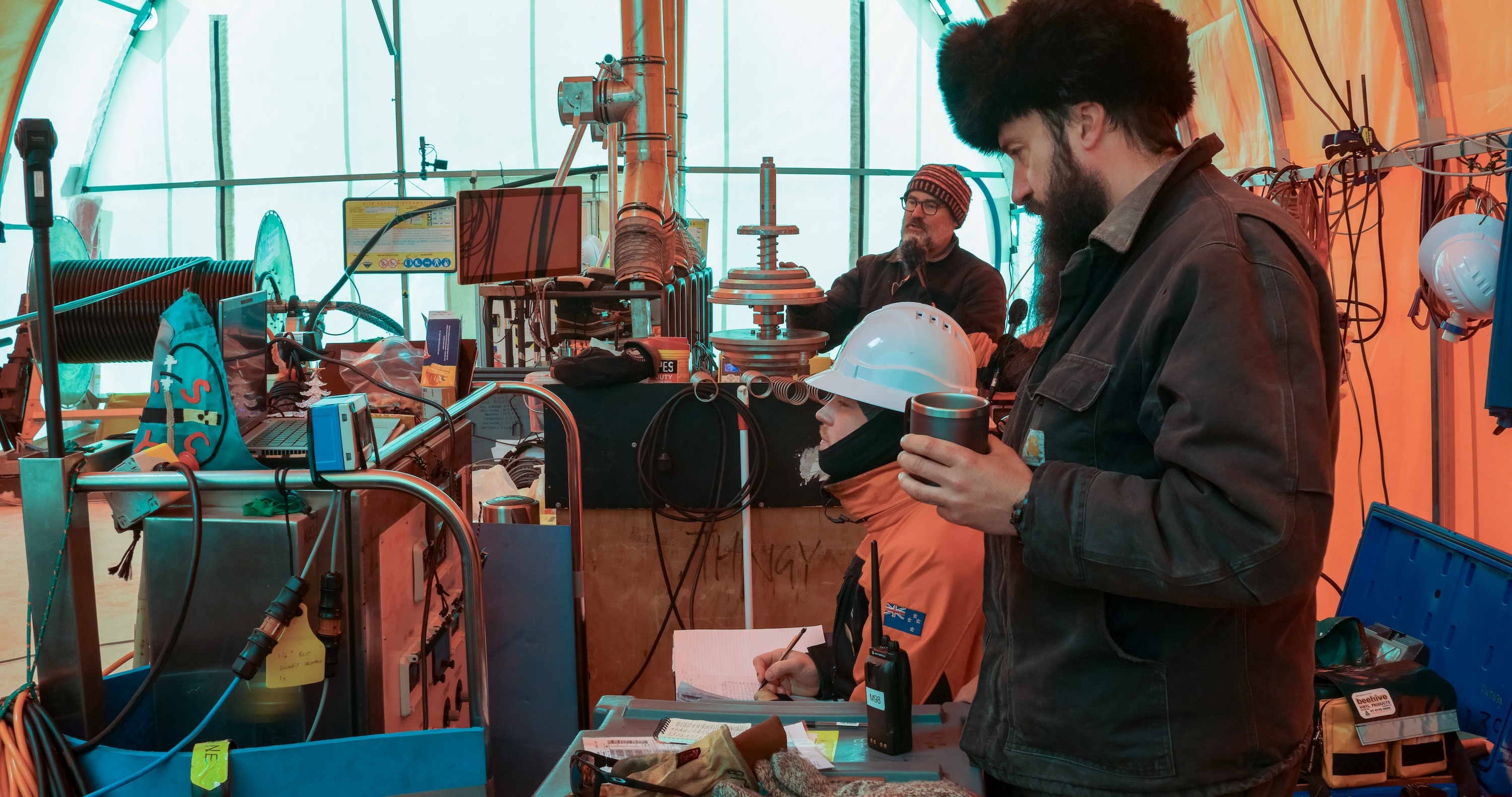
Figure 4: Researchers working inside the drilling tent. Photo: Anthony Powell/Antarctica New Zealand.
This case study was prepared as part of the Platform’s annual reporting to the Ministry of Business, Innovation and Employment for the 2024/25 contract year. It describes how the Platform has been instrumental in an international collaboration that seeks to provide critical historical data to better understand the stability of the West Antarctic Ice Sheet and project its future behaviour.